Home Search Gallery How-To Books Links Workshops About Contact
Garmin
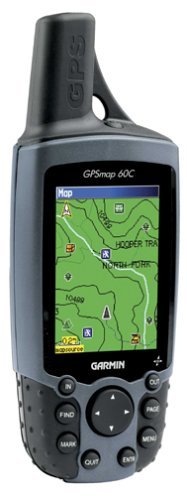
GPSMAP 60C
Pocket Navigator
I've bought TWO of them here and I got the maps here INTRODUCTION This was introduced in August 2004. It completely revolutionizes life because, unlike useless GPS toys of yesteryear, the GPSMAP 60C is the first hand-held GPS that can be loaded with street map and address and telephone data and provide turn-by-turn directions as you drive. The only catch is you need to buy the maps here as well as the GPS unit here and load the maps into the hand held unit using a windows PC before the fun starts. Once you've loaded the maps you no longer need the computer unless you want to update the maps. I used to enjoy navigating by map. What I never realized is not only does this obsolete my skills, but it also serves as a complete telephone and street address directory, even if you don't use it to navigate. Want to find a Mexican restaurant? It will give you a list. Want to find the post office? Again, it will give you a list, with phone numbers. Want to look up L&L Barbeque? You can do it by name and it will give you the phone, address and zip code. This can direct you, turn-by-turn, to anyplace you need to drive, walk, fly, hike or bike. It's super easy to use. It saves you ever having to pay to look up a phone number, address or zip code, since it has this all inside. There is NO monthly cost; it's merely a radio receiver that uses the US military's navigation satellites for which we Americans pay in taxes and for which foreigners pay in fear knowing we use this system to target them to within a foot, any place on Earth. The GPSMap 60C can tell you how long it will take to drive and when you'll get there. Even if you get lost or make a mistake it automatically updates to get you there. No longer do you need to waste $2,000 on a clunky in-dash navigation system that is hard to use and goes out-of date in a year. This unit and map data sell for under $500, and you put it in your pocket to use in any and every car, boat, rental car, bicycle or airplane. Yes, hold it to the window on an airliner and it tells you exactly where you are, how fast you're going, your altitude to the foot and, if you tell it where you're going, will tell you when you'll get there. I also use it on my bicycle. This whole system sell for about what it costs you to buy new data from a car company to update your maps. Also it is super easy to use; I doubt any car system could be as well thought out and intuitive. Not only can it direct you, you can use it like a telephone yellow pages to look up names, addresses and telephone numbers all by itself. You can tell it to find gas or a grocery store or museums or post offices or libraries or etc., and it will list the nearest ones. Select what you want, and it will tell you how to get there. For instance, we were shopping for wedding party favors from a certain chain store. You just type in the name of the store and it gave us the list of where they were, in order of how far away they were! We selected each one and it directed us there. We had to get to about ten different locations for the same store. I'm serious when I say revolutionary. This is so new in a hand held unit that our friends are always astounded when I show them just what it does. I never appreciated just how useful it is until I lived with it for a few weeks. Unlike cell phones proven to cause accidents and deaths, this GPS makes driving safer. (The only reason cell phones are still somewhat legal for use in cars is lobbying by the phone industry.) With the GPSMap 60C keep your eyes on the road at all times instead of being distracted by maps or written directions. Here's what impressed me: you don't even have to take your eyes off the road to read exit signs! You just wait for it to beep to know where to turn. It beeps once telling you it has an instruction for you coming up. Look at it when you can. Then later it beeps twice telling you to do it now. It makes things safer because you can look at it only when it's safe, and not have to read street signs when you're at an intersection or other dangerous times when you need to keep your eyes out for traffic. You can hit the MARK button to mark a point so you can return for photos. Depending on satellite locations it's accurate to twenty feet, usually better, sometimes worse. It knows exactly where you are and exactly how far each upcoming turn is. It's uncanny, and thank billions of dollars spent by the US military since the 1970s to develop this system to target the globe. You're not getting everything for free; the US Military keeps another secretly coded signal to get accuracy to within a foot or better for future use of space-based nuclear-pumped lasers which we'll use to protect freedom worldwide. We'll be able to take out an individual we need to eliminate even while he's enjoying a weekend with his family, and leave the rest untouched; physically anyway. My GPS 60C reads altitude directly from the satellites, usually accurate also to several feet. The people trying to sell you the fancier GPS 60CS model try to claim that GPS altitude is only accurate to 1,000 feet. Baloney; mine is usually correct to a few feet thus better than any barometric altimeter I've used. You don't need to buy the more expensive model GPS 60CS that includes an old-fashioned barometric altimeter; the base model 60C above is more accurate. Of course the fancier model 60CS also reads altitude form the satellites. The reason to get a CS is if you need heading and altitude information when you've lost the satellites. if you use these features on the CS you also suck your batteries faster. I can't say enough good about my GPS 60C. I got one of these for Christmas as a toy. I had no idea that this new model is as revolutionary as the hand-held cell phone was compared to the old bolt-in car phones. I use it in my cars, on my bicycle and out walking around. The speedometer on it is accurate to within a tenth of a MPH, so I use it to calibrate speedometers. I use it for everything when I need to plan any trip. It's so helpful that I'm buying my wife one since she can't live without it either. She loves it also because it has all the phone numbers for stores and everything already in it, so it saves her the $5 a call for information on her cell phone. She loves Macy*s, and she can just ask it to get her to the nearest one when she's in an unfamiliar area. We were getting married in Hawaii, so we just asked the GPS and it told us right where Macy*s was on the garden island of Kauai. Again, it's all free to use. There is no monthly charge like the old On Star, cell phones or other systems. Sun and Moon Of course this GPS, like many, gives rise and set times for the sun and moon, as well as their rough positions in the sky. As shipped it gives tides, however those go away after you've loaded in the maps. If you're a hacker you probably can get tides to work again; I haven't tried. You also can see rise and set times for anywhere on earth and for any time. Pretty handy, huh? Specifications Water resistant Runs on two AA batteries, I get about 20 hours of use with 2,000 mAh Ni-MH rechargeables. You ought to get about 30 hours on a set of Alkalines. Miraculous LCD screen very different from laptop computers and digital cameras; it's perfectly legible in direct sunlight with no backlighting. It also has a light for use in the dark. GPS stands for Global Positioning System. It uses a set of satellites from which one's position is triangulated. You can read here how it works if you're interested. The Catch Catch Number One: You need to buy the maps that load into it separately here and then load them in using a windows PC. Once you've loaded them you don't need the computer any more. The most recent maps are version 7; I bought the version 6 maps and just ordered an upgrade as of 16 August 2005. I ordered the upgrade direct from Garmin since I already own the v6 maps. I found no way to order the v7 maps directly from Amazon where I got my v6 maps originally. 56 MB of memory means it can store everything covering any major metropolitan area or two, like all of Southern California or the New York City tri-state area. I have all of San Diego as well as most of NY loaded into mine. If you make a trip to a new state then you'll want to take about 15 minutes to hook it up to your windows PC to load maps for the area; it can't hold the entire USA. That's the catch: it needs to be hooked up to a windows PC and you need to jerk it around a little to get the maps loaded. Once you get these loaded you'll never again have to hook it up to a PC unless you move or travel to a new state or want to update it. Good news also is you can copy everything you've stored in it, like your trips, on your computer. I use these maps here. Without these maps this navigator is not much more than a toy. With the maps you'll never want to be without it. I even use it at home to look up numbers and plan trips and times. The newest maps, City Select version 6, were introduced in summer 2004. Garmin tends to update them each summer, so make sure you're buying the most recent maps. There is a bizarre unlock process. You can't burn illegal copies for your friends nor can you put your maps on all your friends' GPS. You're really purchasing a licence to use these maps on one individual GPS unit, maybe two if you own them both. You get unlock codes which are keyed to your personal GPS. Good news is it's trivial to install the maps on any PC and load them onto your GPS, but don't get any funny ideas about buying four GPS and splitting the cost of the maps among your roommates. I own no windows PC. It's easy for me to get on any borrowed PC and update my maps. The software is keyed to your GPS unit, not the computer. It will run on any PC as you travel. Catch Number Two: The GPS needs to see the sky to work, where the satellites live. It won't work indoors. It works fine inside cars or held to the window in an airliner. I've never needed to buy an external antenna for inside my car. Some ultra-luxury cars have infra-red reflecting metallic coated windows through which the GPS won't work, but those cars already have their own old-fashioned GPS systems anyway. Oh yeah, it also reads time synchronized to the satellites for setting watches and clocks; no need to wait for radio time signals. Even though the GPS system works by knowing time to fractions of billionths of a second, the display on the GPS is usually off by a fraction of a second. No more than a second, but still not quite as good as WWV radio or here. Recommendations Buy one. I bought two! It's cheaper at Amazon, about $350 here, than anywhere else from what I found. Also get the maps, about $140 here, that make it work for street navigation and look up. Without the maps you'll miss 90% of the reason to get it. It's easy to use if you're the sort of person like me who can program a VCR or set your digital clock. I find the menus and operation intuitive; it's much better than other consumer electronics. On the other hand if you're not willing to load the maps with a PC this might not yet be for you. I'll be loading all the maps on my wife's unit. After that if she can use it easily then I'll know it's for everyone. In a car you can stick this in a cupholder or get a real mounting kit. I use it on my bicycle with the appropriate mount. The GPSMap 60C can do a ton more than I've mentioned. It's as revolutionary as the pocket cell phone; go get one! |


Here are some links for reference. I need to sort these out for you.
http://shop.garmin.com/accessories_for_product.jsp?sku=010-00322-10 (accys)
http://tycho.usno.navy.mil/gps_datafiles.html
http://army-gps.robins.af.mil
http://mapcenter.cgpsmapper.com/
http://cgpsmapper.com/
http://europa.eu.int/comm/dgs/energy_transport/galileo/index_en.htm
http://www.rmbooks.com/books/gps.htm
http://www.gpsdrawing.com
http://ngs.noaa.gov (benchmarks)
http://confluence.org
http://letterboxing.org
www.gpstm.com/eng/dekode_eng.htm
http://www.travelbygps.com/
http://www.jdmcox.com/ aeiral photos
http://www.randmcnally.com
http://www.us.map24.com/
http://www.mapsonus.com/
http://www.viamichelin.com
http://www.multimap.com/
http://mapserver.maptech.com/ topos
CD Emulator
Maps
mapquest
randmcnally
maporama
map24
mapsonus.com
viamichelin.com
multimap.com
yahoo, msn
mapserver.maptech.com
topozone
mapcard
mytopo
Aerial:
teraserver-USA
terrserver.com
nationalmap.usgs.gov
globexplorer
info
gpsinformation.net
vancouver-webpages.com/peter/index.html
doylesdarten.com/gis
macgpspro/html/newhtml/maplibrary.html
lib.berkeley.edu/EART
lib.utexes.edu/maps
oddens.geog.uu.nl/index.html old maps
digitalgrove.net
terrainmap.com
endlesspursuit.com
terraserver.com
terraserver-usa.com